Chasing the winds
Potentially deadly errors in hurricane track prediction
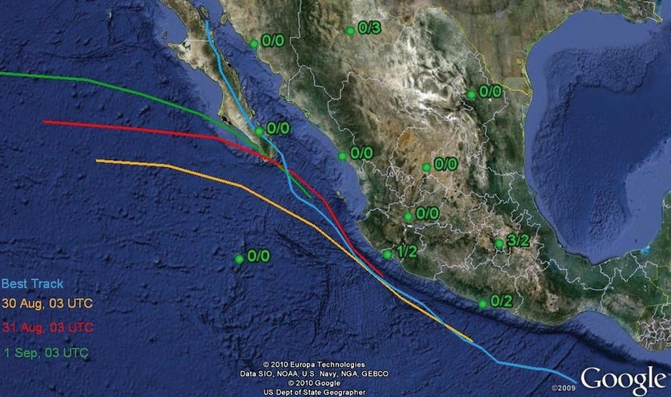
This map shows the Eastern Pacific and Mexico with the Baja California peninsula. The colored lines correspond to the different official forecasts for the track of Hurricane John. John passed through the region between August 30 and September 4, 2006. The forecasts were issued by the National Hurricane Center (NHC) 72 hours (yellow line), 48 hours (red), and 24 hours (green) before landfall. All these forecasts indicated that John would pass out into the Pacific. But, as the blue line of John’s actual trajectory shows, this hurricane made landfall at the Southern tip of Baja California, and then moved through the length of the peninsula, where it produced heavy rains leading to flash-floods and five deaths in several mountain villages, and affecting the State capital La Paz.
The green dots in the graph represent upper air climate monitoring stations and the numbers correspond to upper air soundings with weather balloons in a three-day period at 00 hrs (first digit) and 12 UTC (second digit). Upper air soundings provide crucial data for the numerical models that are used to make the hurricane track predictions. Note that most stations indicate that no balloons were launched during John’s approach.
The Mexican Meteorological Service and the US National Hurricane Center (NHC) jointly work towards more reliable track and intensity forecasts for tropical cyclones. Reliable advance warning of tracks will help save lives and property while possibly also reducing unnecessary evacuations. Analysis by this IAI project suggests that accuracy of the hurricane forecasts was greatly reduced by a critical lack of data from upper air soundings which feed the models used for forecasting. To remedy this situation, transnational collaboration between weather services needs to be strengthened. Data collection with weather balloons needs to be undertaken at regular intervals to provide the minimum four air soundings per day that are required according to the World Meteorological Organization (WMO), and improved output from storm modelling needs to be made available broadly.
Science Snapshots 1 -The Story
The eastern Pacific basin has the largest density of tropical cyclones in the world, yet remains one of the least studied regions. Upon landfall, tropical cyclones may produce heavy downpours, causing landslides and flooding. Mountain ranges run parallel to the coast, both on the continent and the Baja California peninsula, increasing both rain intensities and the incidence of floods and landslides. The Mexican Meteorological Service and the US National Hurricane Center (NHC) issue forecasts of track and intensity for tropical cyclones, which are important for emergency managers to prepare defenses and warn the public. But, as the example shows, these forecasts are not always reliable enough.
To help improve the forecasting, Dr. Graciela Binimelis de Raga and her team at the Universidad Nacional Autónoma de México (UNAM), Centro de Ciencias de la Atmósfera, examined hurricane John in detail. John’s path was fairly typical for mid-summer cyclones, originating in the Gulf of Tehuantepec. Atmospheric conditions intensified the storm, and its passage over an ocean area with elevated heat content increased John to its maximum intensity.
The cyclone forecast issued at 9am on 30th August (yellow line in Figure) predicted no landfall at all. Later forecasts did predict landfall, but only brief contact some 50 km West from the actual landfall site. Only 47 hours before actual landfall, the model predicted an incursion onto land but its track was misplaced, predicting only limited impact from this storm. No predictions showed the actual path moving through the length of the peninsula, which is what brought death and destruction to large swathes of Baja California. In addition, satellite images predicted only moderate amounts (50-150 mm) of rainfall, whereas some weather stations recorded more than 440 mm of rain that resulted in heavy flooding and landslides. The science team identified a lack of airborne atmospheric measurements and a divergence of results between different models as the causes of the predictive failure.
Further reading
Farfán, L.M., R. Romero-Centeno and G.B. Raga: On the landfall of northeastern pacific tropical cyclones John, Lane and Paul (2006) over northwestern Mexico. Monthly Weather Review. http://cabernet.atmosfcu.unam.mx/IAI/files/FarfanEtAl_MWR.pdf (under review)
Global Change Science Snapshots are intended to inform
IAI clients and the interested public about important results of international research carried out under IAI auspices.
Editorial Board Christopher Martius, Ione Anderson, Paula Richter, Holm Tiessen
Design: Shadi Ardalan
Cite as: IAI (2010). Chasing the winds. Potentially deadly errors in hurricane track prediction. Science Snapshots, 3. IAI.
Funded by IAI, NSF under CRN 2048.
Project website: http:// cabernet.atmosfcu.unam.mx /IAI
Download PDF
Download PDF in Spanish