Groundwater use in agriculture risks aquifer over-exploitation
Groundwater use in agriculture risks aquifer over-exploitation
Managing water at the local level in Mexico to buffer against global change
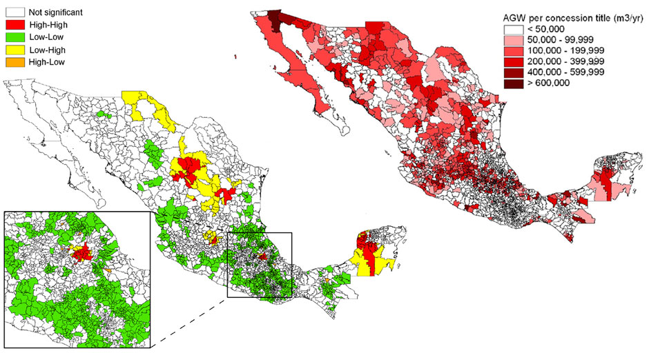
Left: Volume of agricultural groundwater concessioned for use in Mexican municipalities
Right: Comparison of the ratio of ground to surface water use in agriculture for each municipality, clustered with its ten nearest neighbors
The top map of Mexico with all its 2,429 municipalities shows large groundwater titles in the north and center of the country, especially around the Sea of Cortez, the Baja California peninsula and the north-central highlands. The bottom map compares the ratio of ground to surface water use in any one municipality with that of its ten nearest neighbors. In red areas both the municipality and its neighbors use much groundwater so that regional substitution is not an option and groundwater depletion must be managed through reducing demand. In green areas, municipalities and their nearest neighbors use relatively little ground water and pressure on the resource is low. In yellow and orange areas, neighboring municipalities have very different uses of ground and surface waters; therefore, opportunities exist for managing the water supply through transfers or adjustment of water allocations.
Local information on the availability of ground- and surface water is essential for the allocation of water resources. In Mexico, groundwater titles granted by the National Water Commission are key to ensuring future availability of water for multiple human and ecosystem needs. The relationships between ground and surface water used in agriculture vary widely between municipalities. Municipality-scale spatial data make it possible for policy makers to decide if over-exploitation of groundwater can be addressed through reallocations of concessions or must be limited by demand management. These maps from IAI-supported research show critical clusters of municipalities where demand management is needed based on (freely available) municipality-scale water resource data combined with other social, economic and environmental data.
Science Snapshots 9 – The Story
Water is scarce in Mexico’s arid and semiarid North where commercial agriculture is widespread and large volume titles are allocated to users. Groundwater is increasingly used as a buffer against climate-driven variability in surface water flows and as an on-demand source of irrigation of high-value crops for U.S. and global markets. Mexico currently pumps about 29 km3 of groundwater annually, with agriculture using over two-thirds of this total. Groundwater supplies two-thirds of the water used by urban populations, half of the water for industry, and a third of the water for agriculture in Mexico. Water resources are becoming severely over-allocated in some parts of the country, with resulting aquifer depletion, often irreversible water quality degradation, capture of shallow surface flows that sustain riparian habitats, and resource depletion that may come at the cost of future generations.
The Comisión Nacional del Agua currently manages groundwater resources using balances between supply (recharge) and extraction (pumping) at the large scales of river basins and aquifers. The maps show that the degree of ground and surface water exploitation shows great differences at the much smaller scales of individual municipalities within the watersheds. Therefore, the risks of groundwater overexploitation and the management interventions needed vary between municipalities, and data needs to be provided at that scale. IAI-sponsored scientists Christopher A. Scott and Sandy Dall’erba from the University of Arizona together with Rolando Díaz Caravantes from the Universidad Autónoma de Ciudad Juárez prepared spatial analyses using municipality-level data that are publicly available and, hence, low-cost.
Looking at ground- and surface water quantities alone does not explain why water resources are depleted in some municipalities and not in others. However, when agricultural use of both groundwater and surface water resources is examined in relation to the size and location of titled concessions based on data at the municipality scale, specific locations for management of surface water to supplement or substitute groundwater are identified. Maps 1 and 2 show this for the groundwater resources. Similar maps are available for surface water. The implications for other, non-agricultural water uses currently and in the future are also important for inter-generational equity.
Further reading
Christopher A. Scott, Sandy Dall’erba, and Rolando Díaz Caravantes (2010). Groundwater rights in Mexican agriculture: spatial distribution and demographic determinants. The Professional Geographer 62(1): 1-15. Link to this article: http://dx.doi.org/10.1080/00330120903375837
Global Change Science Snapshots are intended to inform IAI clients and the interested public about important results of international research carried out under IAI auspices.
Editorial Board: Christopher Martius, Ione Anderson, Paula Richter, Holm Tiessen
Design: Shadi Ardalan
Cite as: IAI (2011): Groundwater use in agriculture risks aquifer over-exploitation: Managing water at the local level in Mexico to buffer against global change. Science Snapshots 9
Funded by IAI, NSF under SGP-HD 005.
Project web page
Download PDF
Download PDF in Spanish